We did it! In 11 days, we hiked 130 miles. Our feet are tired. Here’s our route — starting in Tahoe City and working our way clockwise:
What a memorable experience — both for its highs (amazing views, peaceful surroundings) and lows (bloody boogers the whole time, dried up lakes). We’ve got lots of lessons learned, fun tidbits, and, of course, photos. Enjoy!
/ FAVORITE EXPERIENCES /
- Chris: “On our second day, finding water — after getting lost and running out of water. Pretty much any time we found water.”
- Chuck: “Realizing I like uphills more than downhills. And seeing that my car was still there at the end! That made me very happy.”
- Tamara: “I liked when we were all bathing in the creek like hobos and people were walking by. And when the guy at the pizza place said, ‘I like your hat, sir.’” (See Day 4)
/ WHAT WE’D DO DIFFERENTLY NEXT TIME /
- We had way too much food. All of us. And it’s crazy heavy when you also have to load up on water. We all unloaded some at our rest stop. Everything else on the packing list was mostly useful.
- Bring more socks — and tape. Chris was the only one who brought two pairs of hiking socks. My dad brought one, and I brought one plus a pair of cotton socks for when we were at camp. My dad and I each bought another pair in South Lake Tahoe. Also, tape and 2nd Skin were the most useful things we brought to cut down on the friction in our shoes.
- If no rain, use a bivvy instead of a tent. Our tent weighed a lot, especially since it’s not a backpacking tent. My dad’s bivvy was light and easy to set up/break down.
/ THE PHYSICAL AFTERMATH /
- Chris: A few sore spots where his pack rubbed against his collarbone; swollen ankle
- Chuck: Giant calluses on the heels of his feet
- Tamara: “Christmas Toes” — numb big toes, named as such because the feeling should return by Christmas
/ THE GOOD STUFF: DAY-BY-DAY AND PHOTOS /
Chris, being the wonderful person he is, kept a brief day-by-day trail journal while I served as photographer for most of the trip. My dad’s job was to set the pace and play the role of cranky old man. 🙂
Day 1 – August 31
Miles hiked: 6
Elevation low/high in feet: sea level/6,400/7,400
Chuck picked us up at 8:30am in San Ramon and we hit the trail in Tahoe City at 1:00pm. Made it somewhere unknown before making camp and passing out for the night before the sun even went down. We couldn’t identify any landmarks so we’re not really sure how far we hiked. Tough first day with lots of climbing and little oxygen!

Trail head signage
Day 2 – September 1
Miles hiked: 13
Elevation low/high in feet: 7,000/7,700
Tough day! Started past Cinder Cone (we think) and made it to the Brockway Summit trail head. Got lost along the way and ran out of water. Eventually found water and the trail at Watson Creek. Phew.
Day 3 – September 2
Miles hiked: 11
Elevation low/high in feet: 7,000/9,700
Started at Brockway Summit trail head and camped at Gray Lake. Climbed 2,700 feet today! Ran out of water about an hour from the lake. Celebrated the day’s hike with birthday Snickers.

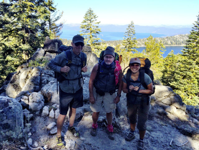
At the top of Mt. Baldy

From Mt. Baldy, which is right after crossing from California to Nevada

Maintaining the journal on Mt. Baldy
Day 4 – September 3
Miles hiked: 11
Elevation low/high in feet: 7,600/10,300
A squirrel ate Chuck’s hat last night. Started at Gray Lake and camped at Ophir Creek. The ascent to Relay Peak was tough! Climbed to 10,338 feet, the highest point on the trail. Highlight of the day was bathing and doing laundry at Ophir Creek which runs through a heavily used public park. It’s good to be clean! Looking forward to a relatively flat day tomorrow.

Squirrel hat

Smiles after reaching Relay Peak

Looking out from Relay Peak
Day 5 – September 4
Miles hiked: 12
Elevation low/high in feet: 7,900/8,600
Started at Ophir Creek and made it to Markette Peak camp. First eight miles to Tunnel Creek Road were the easiest and best trail we’ve had yet. Relatively flat and really well maintained. Campsite is semi-developed with picnic tables, primitive toilet, bear boxes, and a water well! We love easy access to water. Beautiful trail all day with huge boulders, lots of trees, and vistas. Met another hiker, Lorenzo, at camp. He gave us a bunch of good recommendations about places to camp and where to get water. He may hike with us part of the day tomorrow.

Photo courtesy of Lorenzo
Day 6 – September 5
Miles hiked: 13
Elevation low/high in feet: 7,100/8,900
Hiked from Marlette Peak camp to Genoa Peak road. We had planned to get water during the day from Spooner Lake which was nine miles from camp, but Lorenzo told us it’s mostly mud so we loaded up at camp before heading out. Next water source is 25 miles away! Lorenzo guided us the first nine miles to Spooner. We took a long rest, taped up each other’s feet, and made our the remaining three miles to camp.
On the trail with Marlette Lake in the background (Photo courtesy of Lorenzo)

On our way past Snow Valley Peak (Photo courtesy of Lorenzo)

“Gimme all your trail mix!” – Trail Bandita (Photo courtesy of Lorenzo)

The prompt here was, “Look like you’re having fun!”

Our modest little camp and stump kitchen

The sun setting over the forest

More sunsets
Day 7 – September 6
Miles hiked: 11
Elevation low/high in feet: 7,100/8,800
Hiked from Genoa Peak road to Kingsbury Grade. First third of the trail was rocky and hard to hike. The rest was mostly uncovered and very hot. We were on water rations all day since we hadn’t filled up since yesterday morning. Saw the then-first-place runner in a 200-mile endurance run. We thought there would be a 7-11 at the road, but there wasn’t. We ended up catching a ride with a construction pilot car most of the way into town before taking a cab the rest of the way. We spent the night at the Mellow Mountain Hostel where we showered, did laundry, and got a good night’s rest.
Day 8 – September 7
Miles hiked: 0
Elevation low/high in feet: 6,400/6,400
We decided to take a rest day in South Lake Tahoe to let our bodies heal. We’ll pick up the trail again tomorrow at Echo Lake, which will take about 40 miles off the hike. At first we didn’t want to, but it made the most sense because we want to go where there’s water. Chuck bought new shoes, we dumped a bunch of unneeded items from our packs (mostly food), bought a few items we really liked having on the trail (jerky, bagels, bear claws), watched a movie (The Hundred Foot Journey), and ate both breakfast and dinner at Carrows. Great day!

Hanging out in the common room
Day 9 – September 8
Miles hiked: 12
Elevation low/high in feet: 7,500/8,300
Got a ride to Echo Lake trail head from Elias who was co-owner of the Mellow Mountain hostel. Almost didn’t go because it was raining! But it eventually stopped. Spent the night at Gilmore Lake. The first three miles of trail around Echo Lake were flat and well maintained. After that the trail became VERY rocky which made for slow going. We passed a number of amazing alpine lakes and had lunch next to Lake Aloha.

Echo Lake — the water taxi was already closed for the season!

Hiking through the Desolation Wilderness

This portion of the Tahoe Rim Trail follows the Pacific Crest Trail

Lake Aloha

Rocky trail past Heather Lake

Lounging by Heather Lake

More Heather Lake

Resting by Lake Gilmore

A nice foot soak in Lake Gilmore
Day 10 – September 9
Miles hiked: 11
Elevation low/high in feet: 7,800/9,400
Started at Gilmore Lake and camped a little past Phipps Creek. The climb up Dick’s Pass was tough, but the views were great. The trail was wonderful all day and not at all rocky. Had a peaceful lunch at Fontanillis lake and saw a marmot!

The top of Dick’s Pass

Dick’s Lake
Day 11 – September 10
Miles hiked: 16
Elevation low/high in feet: 7,000/8,400
Went from Phipps Creek to Twin Peaks. We didn’t mean to hike so far but we missed our intended campsite at North Fork Blackwood Creek campsite and the next flat place to camp ended up being at the top of Twin Peaks which was three uphill miles away. Got there right as the sun was setting. Beautiful sunset from the top. Trail was nice all day and we saw some amazing scenery. Both Miller Creek and Bear Creek were unexpectedly dry and we thought we were going to run out of water again but found a good flowing creek that wasn’t on the map about a mile past Bear Creek. Long day but we’re all in really good hiking shape now.

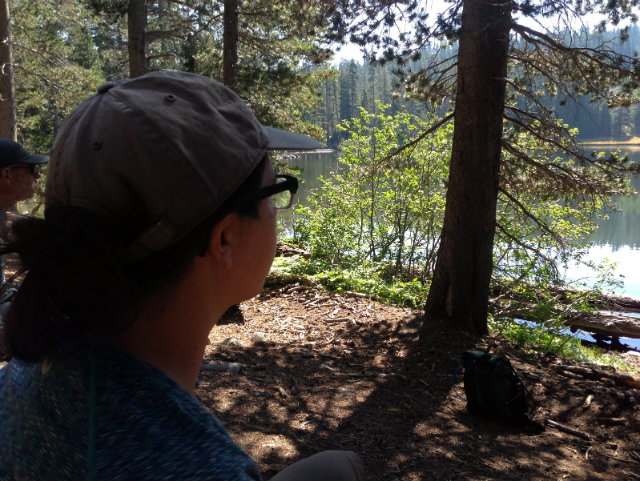
Richardson Lake

My dad looking contemplative and/or grouchy at Richardson Lake

The small creek that saved us!

Looking out from Barker Pass

Trail signage

On our way to Twin Peaks

Sunset from Twin Peaks
Day 12 – September 11
Miles hiked: 12
Elevation low/high in feet: 6,400/8,400
Last day! Hiked from Twin Peaks to Tahoe City. It was an easy day, mostly downhill, and we finished before 2:00pm. Chuck’s car was still in the parking lot and it even started which was a big relief! We stayed the night in Tahoe City and had a big celebratory dinner at Rosie’s. We’re all really proud of ourselves, but also glad to be done.

Sunrise over Lake Tahoe

On our way down from Twin Peaks…

…and down to Ward Canyon

Almost there!

Chris and my dad couldn’t wait to get their packs off

Feet that’re made for (some serious) walkin’
